Primary tabs
Sunday
Add to Calendar
(not available for past events)
 Pre-registration is required and will open Monday, April 6 at 6pm. It will close on Saturday, April 11 at 12 noon.
There will be no day-of registration.
Orienteering at Morven Park
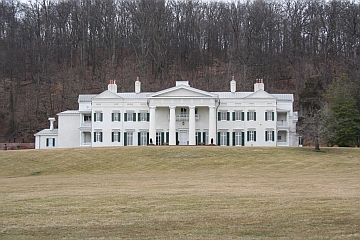
Welcome back to Morven Park! This season’s event in Loudoun County will be run by Chief Martinez (Ret.) and the Naval Junior Reserve Office Training Corps cadets from Loudoun County High School. Course Setter Sam Listwak has prepared a set of 6 classic orienteering courses (White through Red) for this event. To view the Morven Park parking and check-in locations, see our locator map.A National Register Historic Property, Morven Park was for 40 years the home of Virginia Gov. Westmoreland Davis. Now a private park, more than 100,000 people visit it each year, primarily for its equestrian center and courses, museums, historic gardens, sports fields and festivals.
Reminder: White’s Ferry remains closed (so don't plan to use it to get to or from this event!)
What to Expect: Participants will navigate through diverse terrains, including wooded areas, open fields, and waterways, using a map and compass. This event is designed to test your navigation skills, endurance, and for groups, teamwork. Various courses will be available to accommodate all skill levels:
- Beginner Courses (white and yellow): Perfect for newcomers, offering a gentle introduction to orienteering with straightforward checkpoints and kid-friendly terrain. Beginner Instruction will be available.
- Intermediate Course (orange): A bit more challenging, great for those with some orienteering experience looking to improve their skills and navigate off-trail.
- Advanced Courses: For experienced orienteers seeking a rigorous and demanding course with complex navigation.
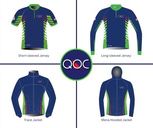 Back By Popular Demand - Jersey & Jacket Orders: Come check out the custom QOC jerseys and confirm your preferred size and style! We'll have them on display at this event (and at next week's event) from ~10:30am - 12pm. Orders must be placed by April 30; details are here.
What to Bring: Participants should come prepared with the following items:
- Comfortable outdoor clothing and sturdy footwear
- Water bottle and snacks
- Compass and whistle if you have them. Loaners are available if needed.
Beginners: Make sure to check out our Your First Event and For Beginners webpages, and if they don't answer all your questions, just ask them via our Contact Form . We will also offer beginner instruction at the event.
Groups: QOC allows groups of up to 4 people to orienteer together. Please see our Group Leaders webpage webpage and then contact the Event Director so they are aware of your plans.
 Apres-Event: As in past years, some folks may head to the Vanish Farmwoods Brewery, located here, just 8.5 miles north of Morven Park off of Route 15. Vanish serves a great selection of pub grub - bar snacks, wood fired pizzas, BBQ, burgers, oysters plus more - and features both wine and 20+ beers brewed on site with local ingredients. See the Vanish website for more information.
Other notes and reminders:
- QOC will continue to use pre-registration as the ONLY method of signing up for our events. There will be NO day-of, on-site registration. Refunds are paid only in case of event cancellation.
- No water or food will be provided. Participants are responsible for meeting all their own food and hydration needs.
- Port-a-johns will be located near the check-in/start/finish.
- Everyone must be out of the woods and back at the registration/finish area no later than 3:00pm, when control pick-up will start. Allow yourself time to get back to the registration area to download, regardless of whether you finished the course. We want to ensure that all participants are safe and accounted for.
- Pets are allowed but must always be kept on a leash and under the owner’s control.
| Volunteers |
|
|||||||||||||||||||||||||||||||||||
|---|---|---|---|---|---|---|---|---|---|---|---|---|---|---|---|---|---|---|---|---|---|---|---|---|---|---|---|---|---|---|---|---|---|---|---|---|
| Course Details |
|
|||||||||||||||||||||||||||||||||||
| Course Notes |
Originally a one-person relay (Motala) was planned and courses designed for that particular type of event. However, due to a conflicting equestrian event on the same day in the park, the area in which the relay was to be set could not be used. Therefore, we are going to Plan B, a Classic event. Six courses will be offered, sorry, no Beige this time, just could not get enough advanced level controls in the distance and climb constraints for this particular course. Also, no Blue, the park is just not large enough.
A few comments on the park. Think of orienteering in this park as a cross country race with orienteering control points. Fast, mostly wide open terrain across fields with good visibility. The park has even cleared out some of the nasty vegetation under the tree lines that used to separate the fields, making the running even faster (and unfortunately the controls more visible). The advanced courses, Brown, Green and Red, will venture into the forested hillside where there will be less visible more technically challenged control locations as well as having their share of controls located in the open terrain. There are many man-made features indicated on the map by Black Xs, these are usually equestrian related obstacles (i.e. jumps). Only the permanent ones are mapped and used as control locations. On any given weekend additional temporary obstacles may or may not appear in the terrain as the park moves the temporary ones around for any events that they may have scheduled. These extra features will only add to the fun as the runner will have to sift through the temporary obstacles to locate the permanent ones where a control bag may be located. While running in the open forested portion of the park, be aware that there are areas of small unmapped rock underneath the leaf cover that may or may not be apparent and may effect ones footing. As an aside, the competing equestrian event is: “Mounted Games Across America”, which features mounted team relay races that test a rider’s speed and agility (promo video here). So, after finishing your race, you might want to wander over to the arena area of the park and do a little spectating. |
|||||||||||||||||||||||||||||||||||
| Registration | Advance registration will be required. The date and time that registration will open will be posted here; usually, registration will open at 6pm on the Monday before the event. |
|||||||||||||||||||||||||||||||||||
| Schedule |
|
|||||||||||||||||||||||||||||||||||
| Location | Athletic Fields Parking | |||||||||||||||||||||||||||||||||||
| Driving Directions |
From the south via the Dulles VA-267 Toll Road, following VA 267 until it terminates, at which point turn onto the US 15 Leesburg Bypass in the direction of US 15 North; if you are coming via VA 7, turn right onto the US 15 Leesburg Bypass and follow it to US 15 North. 300 meters after merging onto US 15 North, turn left onto Tutt Lane, following QOC signage to the parking area.
NOTE: as of June 2021, White's Ferry has been closed.
From the north, follow US 15 South; look for signs for US 15 Bypass and Business 15; 300 m before the junction of US 15 with Business 15 and the US 15 Bypass, turn right onto Tutt Lane, following QOC signage to the parking area.
|
|||||||||||||||||||||||||||||||||||
| Entry Fees | Individual Entries Note: juniors = under 21
Group Entries Participants are welcome to orienteer together as a group (up to the maximum for that event; usually 4). Each member of a group is charged their individual rate as shown above, up to a group total of $30 (maximum), and each receives a map. A group receives one epunch. Individuals or groups desiring to compete on a second course after completing their first can do so for a reduced fee of $2/map subject to approval at the event by the Event Director. Important Notes
|
Course Details
| Course Name | Length (km) | Climb (m) | No. Controls | Scale |
|---|---|---|---|---|
| White | 1.9 | 40 | 8 | |
| Yellow | 2.2 | 30 | 8 | |
| Orange | 3.5 | 55 | 11 | |
| Brown | 4.5 | 130 | 11 | |
| Green | 6.2 | 160 | 17 | |
| Red | 8.4 | 210 | 23 |
Course Notes
A few comments on the park. Think of orienteering in this park as a cross country race with orienteering control points. Fast, mostly wide open terrain across fields with good visibility. The park has even cleared out some of the nasty vegetation under the tree lines that used to separate the fields, making the running even faster (and unfortunately the controls more visible). The advanced courses, Brown, Green and Red, will venture into the forested hillside where there will be less visible more technically challenged control locations as well as having their share of controls located in the open terrain.
There are many man-made features indicated on the map by Black Xs, these are usually equestrian related obstacles (i.e. jumps). Only the permanent ones are mapped and used as control locations. On any given weekend additional temporary obstacles may or may not appear in the terrain as the park moves the temporary ones around for any events that they may have scheduled. These extra features will only add to the fun as the runner will have to sift through the temporary obstacles to locate the permanent ones where a control bag may be located.
While running in the open forested portion of the park, be aware that there are areas of small unmapped rock underneath the leaf cover that may or may not be apparent and may effect ones footing.
As an aside, the competing equestrian event is: “Mounted Games Across America”, which features mounted team relay races that test a rider’s speed and agility (promo video here). So, after finishing your race, you might want to wander over to the arena area of the park and do a little spectating.
Registration
Advance registration will be required. The date and time that registration will open will be posted here; usually, registration will open at 6pm on the Monday before the event.
Schedule
-
Sunday, April 12
6:00 am - 11:00 am
Location
Driving Directions
Entry Fees
Individual Entries
Note: juniors = under 21
| Club Member, adult | Club Member, junior | Non-Member, adult | Non-Member, junior |
|---|---|---|---|
| $10 | $5 | $20 | $5 |
Group Entries
Participants are welcome to orienteer together as a group (up to the maximum for that event; usually 4). Each member of a group is charged their individual rate as shown above, up to a group total of $30 (maximum), and each receives a map. A group receives one epunch. Individuals or groups desiring to compete on a second course after completing their first can do so for a reduced fee of $2/map subject to approval at the event by the Event Director.
Important Notes
- If you wish to become a QOC member you should join online in advance via this webpage (which also explains the member benefits). Membership is completely optional.
- Most of our events use an 'epunch' timing chip for electronic timing. Individuals or groups without their own epunch will be loaned one for that event. Loaned epunches that are lost incur a $40 replacement fee. Epunches (also known as SI-cards or finger sticks) can be purchased from online vendors as described here.
- Former QOC members who have let their membership lapse pay non-member fees.
- Compasses are available at no charge, but if lost incur a $15 replacement fee.
- Please provide collateral (such as car keys) when borrowing a compass or epunch.
- Beginners are encouraged to watch relevant videos such as this one created by QOC's instructional guru David Onkst



