 Printer-friendly version
 PDF versionShareThis
February 9
Sunday
 2020 marks our return to the Camp Wilson area of Pohick Bay Regional Park (PBRP) for the first time since 2017. Daniel Heimgartner is designing a full set of courses, white through blue.
Event timing is our usual: register between 10:45 - 1:15, start any time between 11 - 1:30, be back before 3pm. Registration will be at the Camp Wilson wash house easily visible next to the camp road as you enter Camp Wilson.
Once again, the Green, Red, and Blue courses will entail a road crossing from PBRP across Gunston Road and onto a section of Meadowood Special Recreation Management Area (SRMA.) For an overview of the areas being used for this event, see this map.
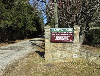
The entrance to Camp Wilson is SEPARATE AND DISTINCT from the park main entrance that many of you are used to using (see photo to the right). It is located just before the Gunston Fire Station. It's easy to miss, so slow down after you pass the entrance to the Pohick Golf Course and be on the look-out for the event signs.
PBRP has made another enlargement of the parking area at Camp Wilson since we last used it in 2017, so we should be able to fit most participant's cars in parking slots. But we will still have overflow parking in the camping areas off the access road as needed. Buses will park in the far rear of the Camp Wilson area next to the disused Scout Hall.
No parking is permitted along the sides of the Camp Wilson entrance road, except in designated slots, in order to avoid any impediment to emergency-vehicle access. As you enter Camp Wilson, look for a parking volunteer in a reflective vest who will direct you to the appropriate parking areas and spaces.
Important notes:

For the courses crossing Gunston Road, there will be controls on both sides of the designated crossing point (see course notes). This point, just adjacent to the Camp Wilson entrance and clearly marked on the pavement, is the only permissible crossing point to and from Meadowood. The visibility from the crossing point in both directions along Gunston Road is excellent, but the speed limit is 50 MPH and cars often exceed that speed, so make sure to stop and observe carefully before crossing. A road guard, wearing a reflective vest, will be in place at the Gunston Road crossing point to watch for approaching vehicles and warn them, as necessary, that there is foot traffic at the crossing point.
Do not cross any part of the Pohick Bay Golf Course, which is located north of Camp Wilson.
You may encounter horses and riders on Meadowood East, which is a local center of equestrian activity and features trails specially designed to withstand the effects of horse traffic. When moving near a horse and rider, please slow down until you pass them and yield the right of way, if you encounter one while running on a trail.
April through October: kayaks and canoes may be rented for an hour or all day to explore Belmont Bay and Kane's Creek. It's a great way to see eagles; details are on the park website.
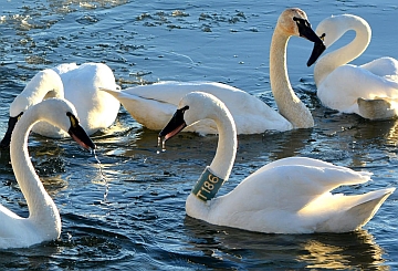
Alaskan tundra swans over-wintering nearby may still be seen (WashPost article about them is here).{thanks to Sid Sachs for this suggestion}
| Location | Pohick Bay Regional Park, Camp Wilson, Lorton, VA (Classic) |
| Registration | No advance registration required. Just show up and have fun! |
| Start Times | Start any time between the specified times (usually 11am - 1:30pm). |
| Schedule | Sunday, February 9| 11:00 am - 3:00 pm | Classic: |
|
| Volunteers | |
| Location Details | Classic
Pohick Bay Regional Park
Camp Wilson
Lorton, VA
Google Map | From I-95 exit 163 (Lorton Rd, VA-642), head east, then turn right/south on Rt 1 (Richmond Hwy). Turn left on Rt 600/242 (Gunston Rd), and then drive 1.5 miles until and turn left on a dirt road marked by a Camp Wilson sign, immediately before the Gunston Fire Station. If you see the main entrance to Pohick Bay Park you've gone too far.
Google Maps Link
Apple/iPhone Link |
|
| Course Details | Classic| Course Name | Length (km) | Climb (m) | No. Controls | | White | 3.1 | 95 | 10 | | Yellow | 4.2 | 110 | 11 | | Orange | 4.5 | 115 | 9 | | Brown | 4.9 | 165 | 9 | | Green | 6.7 | 180 | 15 | | Red | 9.7 | 245 | 20 | | Blue | 12.4 | 275 | 26 |
|
| Course Notes | Classic For all runners:
- Do not cross into any part of the Pohick Bay Golf Course or the fenced horse meadows. They are Out-Of-Bounds areas indicated by pink cross-hatching. There is another Out-Of-Bounds symbol used on both maps, indicated by “puke” green. This indicates Private Property, and we don’t have permission to use the land. Please respect and do not enter these properties.
- Please pay attention running near the finish and start, as there will be cars driving through the campground area for parking.
- Today maybe good occasion to move up from a White to a Yellow course.
- The Blue course has some very steep sections on it.
Special notes for Green, Red, and Blue runners for Meadowood map:
- When crossing Gunston Road, there will be controls on both sides of the designated crossing point (it is painted on the pavement). The visibility from the crossing point in both directions along Gunston Road is excellent, but the speed limit is 50 MPH and cars often exceed that speed. So, make sure to stop and observe carefully before crossing. Road guards, wearing a reflective vest, will be in place at the Gunston Road crossing point to watch for approaching vehicles and warn them, as necessary, that there is foot traffic at the crossing point.
- You may encounter horses and riders. When moving near a horse and rider, please slow down until you pass them and yield the right of way, if you encounter one while running on a trail.
- Ignore the signs that are stating that certain areas are closed for restoration.
- The first loop (on the Pohick Bay map) ends with a control on a “sawhorse” on the E side of Gunston Road. Punch it, to stop the time. Afterwards, you will cross (carefully) the road. There will be another control on a “sawhorse”. Punch it (and perhaps drink some water) to start the time again. Now you proceed to the next control as indicated on the Meadowood map (on the back), according to Out-Of-Bounds symbols.
- Again, you must punch both controls when you come from Meadowood and again when you cross back to Pohick Bay. Your road crossing times will be subtracted from your final course time, so please take your time, look both ways, and cross the road safely. There will also be water at the road crossing, marked on both your map and clue sheet. In summary, you will punch TWO controls twice – one each on either side of Gunston Road.
Map Notes for both areas:
The scale for both maps is 1:10,000 or larger for the shorter courses. The contour interval is 5 meters and is also the same for both maps.
Some of the trails may be difficult to see, due to fallen leaves.
Be aware that because we are using a combination of two maps for some courses (Pohick Bay and Meadowood), you can expect a noticeable change in mapping style (a different look) when you cross the road. Although both maps have exactly the same scale and contour interval, the Pohick Bay map has many form lines (intermediate contour lines to show the terrain between the regular lines). This makes that area appear to be much steeper because of more brown color.
Even though the Pohick Bay map is only a year old, many changes have taken place. Keg Good and Charles Carrick have made every effort to update the map along the courses, but you may encounter discrepancies if you veer off course.
Common sense is very useful in ten-year old Meadowood. Point features, such as rootstocks or pits, are mostly gone. Sometimes a small hill of dirt or shallow depression is all that is left. For navigation purposes these remains are still on the map. Newer rootstocks were added recently.
For the most part, the woods are open and fast. All rock cliffs (black “combs”) shown on the maps are actually only earth banks (brown “combs”).
Be aware of the many remnants of wire fence.
The majority of the green areas are either densely fallen trees or mountain laurel, rather than thorns. |
| Entry Fees | Individual Entries
Note: juniors = under 21
| |
Club Member, adult |
Club Member, junior |
Non-Member, adult |
Non-Member, junior |
| Epunch Owner |
$5 |
$5 |
$10 |
$5 |
| Epunch Borrower |
$10 |
$5 |
$15 |
$10 |
Team or Group Entries
Participants are welcome to compete together as a single team entry. Teams containing one or more nonmembers are charged the nonmember individual rate. Teams containing one or more adults are charged the adult individual rate. For teams to receive member or junior rates, all members of the team must be members or juniors, respectively. Each extra team map beyond the first is an additional $2. Individuals or teams desiring to compete on a second course can do so for a reduced fee of $2/map.
Important Notes
- If you wish to become a QOC member you should join online in advance via this webpage (which also explains the member benefits). Membership is completely optional.
- Most of our events use an 'epunch' timing chip for electronic timing. Individuals or groups without their own epunch pay a higher entry fee (see above), which includes the loan of an epunch for that event. Loaned epunches that are lost incur a $40 replacement fee. Epunches (also known as SI-cards or finger sticks) can be purchased from online vendors as described here.
- Former QOC members who have let their membership lapse pay non-member fees.
- Compasses are available at no charge, but if lost incur a $15 replacement fee.
- Please provide collateral (driver's license or car keys) when borrowing a compass or epunch.
- For additional safety, whistles are available for sale at $1/each.
- Free beginner instruction is always available - just ask at the registration table.
|
 2020 marks our return to the Camp Wilson area of Pohick Bay Regional Park (PBRP) for the first time since 2017. Daniel Heimgartner is designing a full set of courses, white through blue.

