Upper Marlboro
May 15
Sunday
 The permit for this event has been approved.
Pre-registration is required and will open on Monday, May 9 at 6pm and will close at Noon Saturday May 14. There will be no day-of registration.
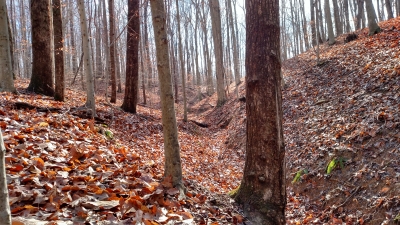
Quantico Orienteering Club is pleased to announce our return to the Upper Marlboro Natural Area. With about 900 acres along the western shore of the Patuxent River, it provides a mix of mid-Atlantic spur and reentrant terrain with Patuxent River lowlands.
Course Setter Matt Smith has prepared a set of classic courses, and details are now below along with updated comments.
COVID Risk Reduction Protocols:
As with all 2021-2022 QOC events, this event requires pre-registration via the link below. QOC’s COVID risk reduction protocols, as also enumerated somewhat here, are in effect. Please read these guidelines carefully. Key points:
- PROPERLY WORN MASKS AND SOCIAL DISTANCING ARE REQUIRED at all times when near registration, epunch and any other areas or queues where volunteers and/or participants are congregating.
- No water will be provided. Provide for your own hydration needs before, during, and after the event.
- There is no planned, on-site beginner instruction, but beginners are encouraged to watch relevant videos such as this one created by QOC's instructional guru David Onkst.
- There will be eight 15 minute check-in windows followed by two 45min windows (as for most QOC events this season).
- Any large groups planning to attend the event or anyone with questions please contact the Event Director.
- The size of start teams (groups of individuals orienteering together with one e-punch) on a course must be no more than four (4) individuals (juniors and adults combined).
- Port-a-johns will be located at the parking area.
- Pets are permitted in the park but must be leashed at all times.
- You're Invited! QOC veteran Sidney Sachs will host a Zoom meeting on Tuesday, May 17 at 8pm to review selected course legs and analyze the routes various orienteers took. Please contact Sid Sachs for the invite link.
| Location | Swanson Road Natural Area, North end, Upper Marlboro, MD (Classic) | ||||||||||||||||||||||||||||||||
| Registration | Registration for this event opens at 6pm on Monday May 9 via this link. Advance registration is required. Registration will close at noon on Saturday May 14 (the day before the event). Who's registered? Check by clicking here. Sorting by column is possible too - just click on the column name. | ||||||||||||||||||||||||||||||||
| Start Times | Start times will be by windows (to be defined for this event before registration opens). | ||||||||||||||||||||||||||||||||
| Schedule | Sunday, May 15
| ||||||||||||||||||||||||||||||||
| Volunteers |
| ||||||||||||||||||||||||||||||||
| Location Details |
| ||||||||||||||||||||||||||||||||
| Course Details | Classic
| ||||||||||||||||||||||||||||||||
| Course Notes | Classic Swanson Rd is such a great area this time of year. There is so much variety of terrain; this area has some of almost everything (and doesn't really have too much of anything.) There is some green but not a lot, and very little thorny. There are big fields and clearings of very different runnability - watch for mowed bush-stumps in some areas. There are areas of strong contouring and areas of subtle contouring and flat areas. Tree foliage is pretty full; where trees are tall and foliage is high visibility is great and the woods will be pretty fast for the most part. Some areas the foliage is lower and visibility is reduced, but white areas will still be very runnable. The Prince George's Radio Control Club has an airstrip in the southern portion of the map. The airfield is awesome and may or may not have planes flying (that typically can be heard from all over the area.) Most courses will get a run-by of this cool facility, however: The Airfield is strictly out-of-bounds; do not cross the airfield; it is not an advantage to any course AND it's out-of-bounds (Green: I've run it both ways and it is not an advantage but don't do it because it's out-of-bounds). Expecting a couple likely showers later this week, there may be some wet &or muddy spots. Is it too obvious to say that mapped seasonal water probably will have water and marshes will be marshy? Still, there's typically a feet-dry route option. There is a lot of deadfall in some of the green-marked lowlands and of course waterways are usually in fairly steep gullies, but vegetation is generally well mapped and any fight is avoidable. There's almost always a variety of route choices, the easiest path is typically not the fastest (but sometimes neither is the hardest or straightest.) The course stats reflect the variety of terrain. While there will be some steepness to your route, it's usually over quickly and these courses don't accumulate a lot of total climb unless you choose to (especially good for those recouping Billygoat-ers.) If you like distance more than climb it may be a good week to run up, but don't underestimate the steep spots in routes you might select. Feedback is always welcome and sought after. Update as of Saturday May 14:
Advanced maps are 1:10,000 In the north, the cultivated fields have crops coming in and are out-of-bounds. For Blue, Red, and Green courses, there is a Mandatory Crossing Point mapped and flagged on the ground and there is a control at the crossing point to eliminate any advantage to crossing the cultivated field. In the south there is what appears to be some kind of bootleg motorcross track with yellow caution streamers between trees (I think marking turns, and path hard to see.) Trees have been cut for this and it is quite sad & illegal…but it is also unmapped. Yellow caution tape should not interfere with routes and can be ignored. Blue X prominent features used for control locations (and marked as well/water prominent feature on clue sheets) are 4 inch white plastic pipe sample wells about 1.5m tall. The Black X prominent feature used as a control location is what I first thought looked like a refrigerator in the woods but is an abandoned outhouse. | ||||||||||||||||||||||||||||||||
| Entry Fees | Individual Entries
Note: juniors = under 21
Group Entries Participants are welcome to orienteer together as a group (up to the maximum for that event; usually 4). Each member of a group is charged their individual rate as shown above, up to a group total of $30 (maximum), and each receives a map. A group receives one epunch. Individuals or groups desiring to compete on a second course after completing their first can do so for a reduced fee of $2/map subject to approval at the event by the Event Director. Important Notes
|