 Printer-friendly version
 PDF versionShareThis
March 2
Sunday
 Pre-registration is required for this event, opening Monday, February 24 at 6pm and closing
Saturday March 1 at 12 noon.
Pre-registration is required for this event, opening Monday, February 24 at 6pm and closing
Saturday March 1 at 12 noon.
There will be no day-of registration.
Welcome back to Kings Landing Park and the Huntingtown Natural Resource Management Area (NRMA). Course setters Mike and Pam Dvorsky have designed a full set of courses for your enjoyment. This year intermediate and advanced courses utilize a remote start and finish in the Huntingtown NRMA. Due to the recent wet weather, no courses will cross Cocktown Creek.
All runners need to check-in and register in the registration area first. Check-in will be in Pavilion #2, and e-punch registration / download will be at the Equestrian Pavilion. Where you start and finish depends on which course you are running:
White and Yellow – Start and finish near the registration area in Kings Landing Park.
Orange, Beige, Brown, Green, Red and Blue – will utilize a remote start and finish in the Huntingtown NRMA. A shuttle will be provided in both directions. The last shuttle back from the NRMA site leaves at 3:05pm.
When you arrive, watch for guidance to the parking area from our volunteers or signs; The road to parking is narrow.
Check-in will open about 9:45am and courses will open at 10:00am. As always, please be off the course by 3pm when we begin to pick up controls. Remote finishers must be back by 3pm to catch the last shuttle. Please remember to download at our e-punch station even if you did not finish. We want to make sure everyone is back and safe. The controls being used at NOT AIR+ enabled.
Shuttles will run in both directions between the registration area and the remote start. Shuttles will leave every 15-20 minutes with the last shuttle leaving the remote start shortly after 3pm. The remote start will be staffed during the
event with a first aid kit and a place to leave clothing and items.
 Volunteer: Sign up for a volunteer slot via this form, or email the Event Director directly for other options.
LIVELOX will be used for this event on all courses. See the instructions on how to use this live GPS tracking by clicking
here. It is especially recommended for use for runners on Orange, Beige, Brown, Green, Red and Blue courses which will be run in the NRMA as there is no vehicle access in that park.
Post-event Social: After your run, grab a bite to eat with fellow orienteers at Chesapeake Grille and Deli, located here, 11 miles from the park. Bring your map and get a free cookie with purchase, courtesy of manager Alexis.
Free Beginner Instruction will be offered, but please reach out to the Event Director if you have a group, so we can plan accordingly. Also, make sure to check out our Your First Event and For Beginners webpages.
Youth Group Leaders: Please see our For Group Leaders page if you are leading a youth or large group – even though you will be pre-registering online. Please contact the Event Director to make them aware of your plans and numbers.
Reminders:
- There is no water on the course. Participants are responsible for their own hydration need before, during and after their courses.
- There will be no food offered by QOC.
- While leashed dogs are technically permitted in Kings Landing and the Huntingtown NRMA, they will not be allowed on the shuttle buses.
- Portable toilets are available in the registration area. There is a permanent portable toilet at the remote start location.
- The size of start teams (groups of individuals orienteering together with one e-punch) on a course must be no more than four (4) individuals (juniors and adults combined).
| Location | King's Landing, Main parking area, Huntingtown, MD (Classic) |
| Registration | Advance registration is required. For this event, registration will open on Monday, February 24 at 6pm and will close at 12 noon on Saturday March 1.
 . .
Who's Registered? Check by clicking here. |
| Start Times | Start times will be by windows (to be defined for this event before registration opens). |
| Schedule | Sunday, March 2| 10:00 am - 3:00 pm | Classic: |
|
| Volunteers | |
| Location Details | Classic
King's Landing
Main parking area
Huntingtown, MD
Google Map | From I-495 (Capital Beltway) exit 11, head S on MD-4 towards Upper Marlboro. In about 22 miles, turn right onto MD-262/Lower Marlboro Rd, go 0.9 miles, then turn left onto Huntingtown Rd. In 2.7 miles turn right onto Kings Landing Rd and follow it ~2 miles into Kings Landing Park. About 100 Ft before the road ends, turn left onto the gravel road to the Equestrian Ring.
Google Maps Link
Apple/iPhone Link |
|
| Course Details | Classic| Course Name | Length (km) | Climb (m) | No. Controls | | White | 2.1 | 40 | 10 | | Yellow | 2.6 | 55 | 11 | | Orange | 4.5 | 95 | 13 | | Beige | 3.2 | 75 | 7 | | Brown | 4.4 | 120 | 10 | | Green | 6.2 | 120 | 11 | | Red | 8.2 | 150 | 12 | | Blue | 10.1 | 170 | 16 |
|
| Course Notes | Classic White and Yellow course runners will start and finish near the registration area.
Orange, Beige, Brown, Green, Red and Blue course runners, after registering for their courses, will board the shuttle bus for a scenic 15 minute drive to the remote start. PLESE NOTE THAT THERE IS NO PARKING AVAILABLE AT THE REMOTE START. DO NOT DRIVE OR PARK THERE. Runners will finish near the remote start, then board the shuttle bus for a 15 minute return trip back to the registration area where they should download their e-punches.
Note on moving up a course: The White, Yellow courses are normal level of difficulty and it would be fine to move up to a harder course. But this is probably NOT a good event to try moving up to Orange or above for the first time. The advanced course legs within the NRMA will demand careful route choices and strong map reading skills, dealing with unmanaged park terrain, an almost total lack of trails, and may be a tad bit more physically challenging.
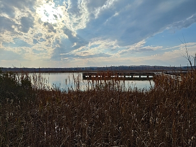
Terrain: The original 260 acre Kings Landing Park map was merged with the newly mapped (2022) 960 acre Huntingtown Natural Resources Management Area (NRMA) which borders to the north to make 1220 acres of orienteering terrain. This is the third QOC event to be held utilizing the NRMA with many map refinements made over the last year. Only Orange and above courses will venture into the wilderness of the NRMA.
There is one paved road that bisects the Kings Landing Park. It is the entrance road and expect cars on this road. Runners should use caution crossing this road. The woods and fields are open and very runnable, and visibility is excellent in both the park and NRMA. Don’t let the easy runnability lull you into a false sense of security. This park has some of the steepest terrain in QOC’s inventory. It looks benign on the drive in, but what you don’t see will give you burning thighs. Parallel errors have been known to happen in this park.
The terrain is classic ridge and valley, with broad, flat ridges, lots of deeply incised spurs and reentrants and large marshes. The slopes are steep and can be as many as four to five contours high. These steep slopes may be slippery if it is or has been raining or snowing. Spiked shoes and gaiters are recommended.
While Kings Landing Park is well-maintained with many manicured areas, the NRMA is just the opposite. With the exception of several cultivated fields which are leased to local farmers, the entire NRMA is an unmanaged, unimproved natural area in the process of being reclaimed by mother nature, with traces of civilization dating back to both colonial times and farming in the 1930’s-1960’s.
White and Yellow Course will be entirely within Kings Landing Park. All other courses will be entirely in the NRMA.
The mapped light green tends to be areas with saplings and closely spaced trees. There is minimal clingy/grabby vegetation except in cleared areas near the road. But dead fall can always be an issue in unmanaged areas like this. Most major areas of deadfall are mapped with vertical green lines, unless they are inside an already marked green area where marking them would just add to confusion.
Individual minor deadfall is generally not mapped unless it blocks a narrow route. The darker green tends to be areas of Mountain Laurel (a woody, stiff evergreen bush) that you can generally struggle to get through, though it will be at a slow walk/crouch and you may have to zig and zag around the stiff branches. They are dense, taller than 6 feet, tend to leave scratches, and can be disorienting. Dark Green means dark green. The visibility is excellent throughout the park except in the Mountain Laurel thickets, which dominate in the central area of the NRMA. The vegetation boundaries should be used judiciously and with caution when navigating in the Mountain Laurel! The rides in the NRMA are in the process of being reclaimed by mother nature. At least one of the mapped rides dates back to colonial Maryland. Some less discernable rides have been mapped as less distinct trails where appropriate. Some parts of the rides may appear more like wide, shallow erosion gullies but if you use your imagination, you can almost visualize the horse and wagon traffic transporting tobacco to market. Don’t expect to use the rides as a clear, quick running path as most are blocked intermittently with deadfall or vegetation. One ride was cleared by hunters this winter so it may prove to be more runnable. All advanced courses will cross the one limited access paved road in the NRMA. It is virtually never used except by the rare park ranger visit or farmer. I expect no traffic on this limited access road and you should be fine to cross it or use it as your route choice dictates. Within the NRMA, there is a large amount of broken ground, particularly along the sides of what once were roads. Only prominent knolls (4ft or higher) are mapped in these areas. In areas away from the broken ground, smaller singular knolls may be mapped. Otherwise, the map would look like it had measles.
This map of the NRMA is a work in progress (and can only be field checked during the non-hunting season!) so any comments on improving the map are welcome. |
| Entry Fees | Individual Entries
Note: juniors = under 21
| |
Club Member, adult |
Club Member, junior |
Non-Member, adult |
Non-Member, junior |
|
$10 |
$5 |
$20 |
$5 |
Group Entries
Participants are welcome to orienteer together as a group (up to the maximum for that event; usually 4). Each member of a group is charged their individual rate as shown above, up to a group total of $30 (maximum), and each receives a map. A group receives one epunch. Individuals or groups desiring to compete on a second course after completing their first can do so for a reduced fee of $2/map subject to approval at the event by the Event Director.
Important Notes
- If you wish to become a QOC member you should join online in advance via this webpage (which also explains the member benefits). Membership is completely optional.
- Most of our events use an 'epunch' timing chip for electronic timing. Individuals or groups without their own epunch will be loaned one for that event. Loaned epunches that are lost incur a $40 replacement fee. Epunches (also known as SI-cards or finger sticks) can be purchased from online vendors as described here.
- Former QOC members who have let their membership lapse pay non-member fees.
- Compasses are available at no charge, but if lost incur a $15 replacement fee.
- Please provide collateral (such as car keys) when borrowing a compass or epunch.
- Beginners are encouraged to watch relevant videos such as this one created by QOC's instructional guru David Onkst.
|