| Location | Directions |
|---|---|
|
Main parking area
Google Maps Link Apple/iPhone Link |
From I-495 (Capital Beltway) exit 11, head S on MD-4 towards Upper Marlboro. In about 22 miles, turn right onto MD-262/Lower Marlboro Rd, go 0.9 miles, then turn left onto Huntingtown Rd. In 2.7 miles turn right onto Kings Landing Rd and follow it ~2 miles into Kings Landing Park. About 100 Ft before the road ends, turn left onto the gravel road to the Equestrian Ring. |
About This Venue
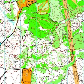
King's Landing is a small county park in Calvert County, Maryland, expanded significantly for orienteering when several hundred adjacent acres of the neighboring Huntingtown Natural Resource Management Area (NRMA) were mapped and opened for QOC's use, bringing the combined orienteering terrain to roughly 1,220 acres.
The park is bisected by a single paved entrance road that carries real car traffic, so courses require caution crossing it. The terrain is classic ridge and valley, with broad, flat ridges and deeply incised spurs and reentrants that can run four to five contours steep and slippery when wet — spiked shoes and gaiters are worth having. It looks benign on the drive in, but this is some of the steepest terrain in QOC's inventory, and parallel errors are common. The NRMA section is unmanaged and still being reclaimed by nature, with traces of colonial-era and 20th-century farming; its center holds dense mountain-laurel thickets that can be disorienting, and its longer courses cross Cocktown Creek, generally 4-8 feet wide with no bridge, at whichever of several marked points a runner prefers. QOC sets its full range of courses here, White through Blue, with the longer, more advanced courses routed into the NRMA from a separate remote start reached by shuttle.
This combination of compact, steep original parkland and open new NRMA terrain makes King's Landing suited to a wide range of orienteers, from beginners on the shorter courses near the main registration area to advanced participants tackling the more remote NRMA-based courses — though the NRMA courses aren't a good place to move up in difficulty for the first time.
Parking access is via a narrow road, so watch for QOC's on-site guidance signs. Check-in and map pickup are typically at the park's Pavilion #2, with e-punch registration and download at the nearby Equestrian Pavilion; a shuttle runs between the two areas throughout the event for participants using the remote NRMA start.
Upcoming Events at this Venue
| From | Event |
|---|---|
| Mar 07 / Sun | King's Landing, Main parking area,Huntingtown, Maryland |
Sample Orienteering Map