Primary tabs
Sunday
Add to Calendar
(not available for past events)
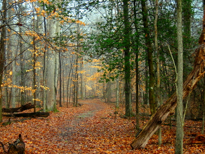 Welcome to Mason Neck - an orienteering venue quite different from most! Unlike typical QOC terrains, Mason Neck has few hills and the map has 5 foot (not 5 meter) contours. The steeper areas are along reentrants leading down to marshes and the tidal water. For the most part, runners will be pleasantly surprised as this park has predominantly open, runnable woods and is generally flat with subtle contour features. There are large areas lacking trails. This can present a real challenge as runners may need to rely on their compass and pace count; for additional tips, make sure to see the course setter notes below.
Full course details - including for the "combined" (white + yellow together) beginner course - and course setter notes are now posted below. Event registration will be from 10:45am - 1:15pm. Start your course anytime between 11am - 1:30pm, but be back before the courses close at 3pm. There is an entrance fee for the park ($5 (in state) or $7 (out-of-state) per car).
REMINDER: Use the cups we provide at each water stop. DO NOT CHUG directly from the water containers. We encourage event directors to void the results of anyone violating this policy. Every orienteer can take the extra few seconds to use the cups.
Park Information:
Mason Neck State Park is also a great place for exploration on the water or by bike (a very smooth and family-friendly bike path runs through much of the park). Of note:
- There's a fine playground quite near our registration area.
- Dogs are welcome in the park, but must be on a leash of length 6 feet or less at all times and "with a human on the other end", as a park ranger said.
- April through October: kayaks and canoes may be rented for an hour or all day to explore Belmont Bay and Kane's Creek. It's a great way to see eagles; details are on the park website.
- Nature Programs for Kids & Families: There are 4 programs (at 10am, 2pm, 3pm, and 5pm) this Sunday at Mason Neck that you might enjoy; details here.
Any youth or large groups attending, please contact the Event Director so that we can coordinate pre-registration for your group; the group registration and waiver form is part of the information on our Group Leaders page.
| Volunteers |
|
|||||||||||||||||||||||||||||||||||||||||||||
|---|---|---|---|---|---|---|---|---|---|---|---|---|---|---|---|---|---|---|---|---|---|---|---|---|---|---|---|---|---|---|---|---|---|---|---|---|---|---|---|---|---|---|---|---|---|---|
| Course Details |
|
|||||||||||||||||||||||||||||||||||||||||||||
| Course Notes |
Mason Neck was the most difficult places I've set controls in in over forty years of setting courses due to the lack of features. I usually plan my legs backward from the control locations to the start of the legs, trying to have several different ways to go. I like to have collecting features near the controls, before the controls of the Orange runners and after for the advanced orienteers. However, that was not possible here. The available pits and knolls are small and there are downed trees all over, making it hard to locate the different features. The woods were very open though, so I am planning to hang the controls so they can be seen from a distance. This means that, for example, instead of hanging a controls directly on a root stock, it will be on a tree near it.
Beginner Courses: I designed them so the last control on White is the first control on Yellow. Both of the courses are a little bit short. Therefore I am offering a "combined" beginner course that combines both white and yellow courses together for those who'd like more running. Orienteers on the white (or combined) course should also be aware that between controls 4 - 5, they should not go north of the trail since the area is protected. Map scale is 1:5000. For the Orange runners, I do not suggest you move up to an advanced course here due to the lack of features; it's very easy to get disoriented. It happened to me each time I went out to check the control placements. Map scale is 1:7500. Advanced orienteers: There are some legs that you will be using that over long distances are totally flat with no collecting features. Map scale is 1:10000. Note to the Blue runners: There is a new trail with a small parking area that is not on the map. I rearranged the legs so you may see it at the beginning of the leg instead of just before the control. |
|||||||||||||||||||||||||||||||||||||||||||||
| Registration | No advance registration required. Just show up and have fun! | |||||||||||||||||||||||||||||||||||||||||||||
| Schedule |
|
|||||||||||||||||||||||||||||||||||||||||||||
| Location | Mason Neck SP, Lorton, Virginia | |||||||||||||||||||||||||||||||||||||||||||||
| Driving Directions |
From southbound I-95, take exit 163 (Lorton). Go left onto Lorton Rd at the end of exit ramp. Go under the 2nd overpass and turn right onto Lorton Market St., then go about 1.5 miles to the traffic light at Route 1. Go straight through light (the road name changes to Gunston Rd) and go about 5 miles to the right turn on High Point Road (it's about 1.2 miles after the Pohick entrance). Once in the park ($10 entrance fee per vehicle), follow the signs towards the Visitor Center. The registration area will be to the left just before the Visitor Center; look for the banner.
|
|||||||||||||||||||||||||||||||||||||||||||||
| Entry Fees | Individual Entries
Note: juniors = under 21
Team or Group Entries Participants are welcome to compete together as a single team entry. Teams containing one or more nonmembers are charged the nonmember individual rate. Teams containing one or more adults are charged the adult individual rate. For teams to receive member or junior rates, all members of the team must be members or juniors, respectively. Each extra team map beyond the first is an additional $2. Individuals or teams desiring to compete on a second course can do so for a reduced fee of $2/map. Important Notes
|
Course Details
| Course Name | Length (km) | Climb (m) | No. Controls | Scale |
|---|---|---|---|---|
| White | 1.7 | 25 | 7 | |
| Yellow | 2.5 | 25 | 10 | |
| Orange | 4.3 | 35 | 11 | |
| Brown | 4.6 | 30 | 8 | |
| Green | 6.1 | 40 | 9 | |
| Red | 7.6 | 50 | 11 | |
| Blue | 9.1 | 60 | 15 | |
| Combined | 3.7 | 50 | 15 |
Course Notes
Beginner Courses: I designed them so the last control on White is the first control on Yellow. Both of the courses are a little bit short. Therefore I am offering a "combined" beginner course that combines both white and yellow courses together for those who'd like more running. Orienteers on the white (or combined) course should also be aware that between controls 4 - 5, they should not go north of the trail since the area is protected. Map scale is 1:5000.
For the Orange runners, I do not suggest you move up to an advanced course here due to the lack of features; it's very easy to get disoriented. It happened to me each time I went out to check the control placements. Map scale is 1:7500.
Advanced orienteers: There are some legs that you will be using that over long distances are totally flat with no collecting features. Map scale is 1:10000. Note to the Blue runners: There is a new trail with a small parking area that is not on the map. I rearranged the legs so you may see it at the beginning of the leg instead of just before the control.
Registration
No advance registration required. Just show up and have fun!
Schedule
-
Sunday, April 30
11:00 am - 3:00 pm
Location
Driving Directions
Entry Fees
Individual Entries
Note: juniors = under 21
| Club Member, adult | Club Member, junior | Non-Member, adult | Non-Member, junior | |
|---|---|---|---|---|
| Epunch Owner | $5 | $5 | $10 | $5 |
| Epunch Borrower | $10 | $5 | $15 | $10 |
Team or Group Entries
Participants are welcome to compete together as a single team entry. Teams containing one or more nonmembers are charged the nonmember individual rate. Teams containing one or more adults are charged the adult individual rate. For teams to receive member or junior rates, all members of the team must be members or juniors, respectively. Each extra team map beyond the first is an additional $2. Individuals or teams desiring to compete on a second course can do so for a reduced fee of $2/map.
Important Notes- At the event, we can only accept payment in cash or check; online, you may use a credit card or PayPal account.
- If you have access to a smartphone, you may become a member at the event by joining online via this webpage (which also explains the member benefits). Membership is completely optional. If you wish to join or renew, we strongly recommend joining (or renewing) online before the event rather than at it to save time and because it's easier.
- Most of our events use an 'epunch' timing chip for electronic timing. Individuals or groups without their own epunch pay a higher entry fee (see above), which includes the loan of an epunch for that event. Loaned epunches that are lost incur a $40 replacement fee. Epunches (also known as SI-cards or finger sticks) are usually available for sale at each event as described here.
- Former QOC members who have let their membership lapse pay non-member fees.
- Compasses are available at no charge, but if lost incur a $15 replacement fee.
- Please provide collateral (driver's license or car keys) when borrowing a compass or epunch.
- For additional safety, whistles are available for sale at $1/each.
- Free beginner instruction is always available - just ask at the registration table.



