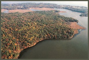
Crow's Nest
November 30
Saturday
 Update: This event is filled to capacity, in other words, SOLD OUT.
This is an unusual event ... it's both an expedition to assess a new venue and a Score-O, set in a park so new that it lacks facilities like parking lots or restrooms, and using a basemap that has been quite minimally fieldchecked. For safety reasons as well as permitting limitations, participation in this event will be limited to at most 40 QOC members with advanced orienteering skills. Registration is now
 open closed. and the sign-up page is located at URL https://www.eventbrite.com/event/9196921239.
Questions? Use our Contact Us form!
Websites describing this area include the VA DCR Crow's Nest Natural Area Preserve page and a description in Wikipedia.
| Location | Crow's Nest, Brooke Rd Parking Area (Exploratory Score-O) | ||||
| Registration | |||||
| Start Times | We will meet at the parking area at 11am, and then carpool into the park. The 2 hour Score-O will go from noon to 2pm. | ||||
| Schedule | Saturday, November 30
| ||||
| Volunteers |
| ||||
| Location Details |
| ||||
| Course Notes | Exploratory Score-O The Course: Score-O with 20 controls (all equal value). 2-hour time limit. Find as many as you can within the time-limit. Overtime penalty: 1 control for every 2 minutes overtime. Approximate distance for all controls: 11km. Approximate climb for all controls: 340m. The Terrain: The Crow's Nest peninsula is characterized by extensive ridge and valley terrain, with steep hillsides. Vegetation is predominantly hardwood forest with very little undergrowth. There are patches of mountain laurel that will slow you down, but they are not impenetrable. There is virtually no rock.
The Map: Scale 1:10,000 with 5-meter contours, printed on 11x17 inch paper. The map was generated from LIDAR data and has not been field checked. Therefore there are some important considerations to keep in mind. | ||||
| Entry Fees | To be determined. |
