Primary tabs
Saturday
Add to Calendar
(not available for past events)
Our permit has been approved and registration is now open (link is below).
There are eight courses to choose from (2 beginner, 1 intermediate, and 5 advanced) thanks to course setters Mike and Pam Dvorsky and supported with map updates from Dave Linthicum. Detailed course notes and updates are posted below and have been updated with some MapRun specifics.
This distributed, GPS Orienteering event requires online pre-registration. Registration is limited to a total of 20 starts (group or individual) per day. QOC’s COVID risk reduction protocols, as also enumerated here, will be in effect. Please read these guidelines carefully. We encourage everyone to download and use any or even all of the DC, Maryland and Virginia COVID exposure notification apps.
This event requires MapRun6 software, available from the Google Play and Apple App stores.
Other points:
- Properly worn masks are required when near other non-family group participants.
- Water will not provided in accordance with QOC COVID-19 risk reduction policies. Bring your own water.
- The nearest restrooms are portapotties located near the Radio Controlled Aircraft field at the end of Swanson Road [Google Maps Link here.] If the gate for southern access to the park is locked, then the next closest restroom will be one of the businesses along Route 301.
- There will be no on-site QOC presence during the event. Unlike other events, there is no safety plan to ensure all participants depart the woods safely. We recommend all participants ensure someone knows their plans and provide some degree of overwatch to confirm your safety. If an emergency arises, call 911.
- For this event, the course controls are pink construction streamers, labeled with handwritten text, e.g., QOC # 31. Although streamers were verified and checked before the first date, it is possible some may have been removed.
- The Start has been streamered. The Finish will not be streamered.
- Start will be the western tip of the first barn when proceeding east along Swanson Road Spur located about 300 m ENE from the parking area. This is QOC’s usual registration site when working from the North part of the park.
- Finish will be the intersection of Swanson Road Spur and the local access road heading to the SE about 200 meters ENE from the parking area. You will pass Finish on your way to the Start.
- The designated parking area is very small and can accommodate no more than a few vehicles. Parking along the shoulder of Swanson Road Spur near the parking area is allowed, provided access for others is not impeded. Please do not block any roads or intersections. See figure.
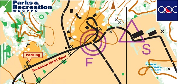
How this should work:
- This is our first fully distributed, multi-day GPS Orienteering event. We have done many trials of the approach with our one-day “COVID-normal” events this season and are pretty confident we have the bugs worked out, but this will be the first full scale event of its type. Please send feedback to the Event Director.
For Participants:
- Choose your preferred day within the event window and register.
- Cost is a flat fee of $ 10 per registration.
- After completing registration and payment on PayPal, you will be presented a button to “Return to the Merchant.”
- Follow that link.
- That will provide access to the printable map files, MapRun Access Codes (PINs), printing instructions, and a MapRun tutorial.
- If you miss this step, contact the Event Director, who will verify your registration and send the link – but this might take a day or two, depending on availability
- If you have not already done so, download and install MapRun6.
- If you want a hard copy map print them from the provided package. Color printing is recommended.
- Come to the Patuxent River Park Upper Marlboro Area on your chosen day and run your course.
- See results on MapRun’s Leader Board here.
- Please participate in QOC’s Course Review after the event concludes. Contact Sidney Sachs for schedule specifics, tentatively planned for 8pm Wednesday, April 14.
- If you notice missing streamers, unsafe conditions, or get injured, please notify the Event Director.
| Volunteers |
|
|||||||||||||||||||||||||||||||||||||||||||||
|---|---|---|---|---|---|---|---|---|---|---|---|---|---|---|---|---|---|---|---|---|---|---|---|---|---|---|---|---|---|---|---|---|---|---|---|---|---|---|---|---|---|---|---|---|---|---|
| Course Details |
|
|||||||||||||||||||||||||||||||||||||||||||||
| Course Notes |
The Patuxent River Park, Upper Marlboro Natural Area provides a mix of mid-Atlantic spur and reentrant terrain, combined with Patuxent River lowlands and marshes, with several creeks and streams. The park also has several open fields leased to local farmers who may or may not have harvested their crops by the day of the meet. Please be careful to not damage their crops. All of the fields are part of the park and can be carefully crossed.
The District Branch of the Patuxent River bisects the old and newly mapped sections of the park and will be crossed by all Beige and above courses. The Spring Branch with similar characteristics will also come into play on the Red and Blue courses. There are no bridges or man-made crossings over the District nor Spring Branch so searching for one will be futile. The banks on both Branches range from a gentle slope to cliffs. The depth of water will be totally dependent upon recent rainfall since the entire Marlboro Natural Area and surrounding area drains into the District and Spring Branch and flows to the Patuxent River. There are good and bad and terrible spots to cross the water so choose wisely. A poor choice will result in a very wet crossing. So be careful with your water crossings! The Radio Control model aircraft field which is located on the Southeast side of the park should not come into play on any course, and if it does, you are in the wrong place. If by some route choice you find yourself next to the field, please do not cross the airfield or interfere with any modelers there. They are friendly but have very strict safety rules about aircraft and people being near each other -- which can get awkward for the uninitiated. If the aircraft are flying, stay near the outside edges of the field, and all should be fine. Finally, the woods are generally very runnable with occasional deadfall from recent wind storms which is not mapped. The undergrowth, particularly around the edges of open areas can be thick and full of thorny vines. Take care when running in those areas as a thorny vine is lurking with your name on it just waiting to wrap around your ankle, trip and scratch you while you are unaware! And depending on how warm things get as we approach our game days, you should expect ticks and mosquitos lying in wait for those that did not put on insect repellent. MapRun details
Within the MapRun app, the path to the files for this event is: As described above, after completing the PayPal process and Returning to the Merchant, you will be presented a link to the printable maps, printing instructions, and basic MapRun tutorial.
Some course specifics:
All MapRun events will accept participants starting Monday, 22 March.
Please review the Settings and Options portion of the tutorial. Brown, Beige, Orange, Yellow, and White course setting will display position and track, but they can be turned off if desired. The “Show Me” feature is enabled for all courses. Streamer survey GPS comments: While surveying the streamers, I reduced my GPS tolerance to 10 meters, instead of the usual 15, and had solid GPS info approaching each control while walking to them. All courses retain the 15 meter punch tolerance, corresponding roughly to the edge of a control circle, and can be throttled down or loosened as desired. Your specifics will almost certainly vary, but remember HITMO is your friend. If for some reason, you do not have a track in MapRun after your run, but did use a GPS watch in parallel, contact the Event Director.
Course Updates |
|||||||||||||||||||||||||||||||||||||||||||||
| Registration | Registration is now open; click this link to register. Registration will close no later than noon, Thursday April 8. Who's registered? Check by clicking here. Sorting by column is possible too - just click on the column name. |
|||||||||||||||||||||||||||||||||||||||||||||
| Schedule |
|
|||||||||||||||||||||||||||||||||||||||||||||
| Location | Swanson Road Natural Area, North end, Upper Marlboro, Maryland | |||||||||||||||||||||||||||||||||||||||||||||
| Driving Directions |
From the Washington Beltway, take exit 11 to MD-4 South/Pennsylvania Avenue. After 8 miles, exit onto US-301 North. Drive 3 miles then turn right onto Swanson Road. Stay on Swanson Road for about half a mile, then instead of turning right for Swanson Road, continue straight onto Swanson Road Spur. Follow Swanson Road Spur for another half mile+ to the parking area.
If your route brings you south on US-301, turn left onto Swanson Road - it's the next junction south of Leeland Road, with the right turn being onto Beech Tree Parkway and the left turn, crossing the highway onto Swanson Road, then follow directions above.
|
|||||||||||||||||||||||||||||||||||||||||||||
| Entry Fees | Flat rate for each registration is $10.
The $10 provides printable map files, access codes, a MapRun tutorial (if needed), OUSA insurance, and printing instructions for courses. Participants are welcome to orienteer together as a group, or individually. If you wish to become a QOC member you should join online in via this webpage (which also explains the member benefits). Membership is optional. |
Course Details
| Course Name | Length (km) | Climb (m) | No. Controls | Scale |
|---|---|---|---|---|
| White | 1.4 | 10 | 8 | |
| Yellow | 2.3 | 50 | 10 | |
| Orange | 4 | 180 | 13 | |
| Beige | 3 | 105 | 9 | |
| Brown | 4.1 | 155 | 12 | |
| Green | 5.9 | 200 | 12 | |
| Red | 8 | 255 | 16 | |
| Blue | 10 | 310 | 18 |
Course Notes
The District Branch of the Patuxent River bisects the old and newly mapped sections of the park and will be crossed by all Beige and above courses. The Spring Branch with similar characteristics will also come into play on the Red and Blue courses. There are no bridges or man-made crossings over the District nor Spring Branch so searching for one will be futile. The banks on both Branches range from a gentle slope to cliffs. The depth of water will be totally dependent upon recent rainfall since the entire Marlboro Natural Area and surrounding area drains into the District and Spring Branch and flows to the Patuxent River. There are good and bad and terrible spots to cross the water so choose wisely. A poor choice will result in a very wet crossing. So be careful with your water crossings!
The Radio Control model aircraft field which is located on the Southeast side of the park should not come into play on any course, and if it does, you are in the wrong place. If by some route choice you find yourself next to the field, please do not cross the airfield or interfere with any modelers there. They are friendly but have very strict safety rules about aircraft and people being near each other -- which can get awkward for the uninitiated. If the aircraft are flying, stay near the outside edges of the field, and all should be fine.
Finally, the woods are generally very runnable with occasional deadfall from recent wind storms which is not mapped. The undergrowth, particularly around the edges of open areas can be thick and full of thorny vines. Take care when running in those areas as a thorny vine is lurking with your name on it just waiting to wrap around your ankle, trip and scratch you while you are unaware!
And depending on how warm things get as we approach our game days, you should expect ticks and mosquitos lying in wait for those that did not put on insect repellent.
MapRun details
Within the MapRun app, the path to the files for this event is:
USA … Mid-Atlantic … Quantico … 2021 03 Upper Marlboro
As described above, after completing the PayPal process and Returning to the Merchant, you will be presented a link to the printable maps, printing instructions, and basic MapRun tutorial.
Some course specifics:
Both Red and Blue courses have a map change. Therefore, there are two files for printed maps. This was necessary to keep all maps standardized on letter size paper.
All MapRun events will accept participants starting Monday, 22 March.
All MapRun events will close at 8 pm on Saturday 10 April (shortly after local sunset).
After that time no further participation will be accepted by the MapRun software.
Please review the Settings and Options portion of the tutorial.
Blue, Red, and Green course settings do not display position or track, but they can be turned on if desired.
Brown, Beige, Orange, Yellow, and White course setting will display position and track, but they can be turned off if desired.
The “Show Me” feature is enabled for all courses.
Streamer survey GPS comments:
While surveying the streamers, I reduced my GPS tolerance to 10 meters, instead of the usual 15, and had solid GPS info approaching each control while walking to them.
All courses retain the 15 meter punch tolerance, corresponding roughly to the edge of a control circle, and can be throttled down or loosened as desired. Your specifics will almost certainly vary, but remember HITMO is your friend. If for some reason, you do not have a track in MapRun after your run, but did use a GPS watch in parallel, contact the Event Director.
Course Updates
An orienteer reported on March 30 that streamer #52, a control shared on Green and Red courses, may be missing.
And on April 2 we got confirmation that streamer #52 is missing, and that streamer #58, a control shared on White, Yellow, Orange and Red courses, may not be present or no longer properly marked.
As of April 4, the issues reported earlier with #52 and #58 have been corrected.
Registration
Registration is now open; click this link to register. Registration will close no later than noon, Thursday April 8.
Who's registered? Check by clicking here. Sorting by column is possible too - just click on the column name.
Schedule
-
Saturday, April 10
6:00 am - 5:00 pm
Location
Driving Directions
If your route brings you south on US-301, turn left onto Swanson Road - it's the next junction south of Leeland Road, with the right turn being onto Beech Tree Parkway and the left turn, crossing the highway onto Swanson Road, then follow directions above.
Entry Fees
Flat rate for each registration is $10.
The $10 provides printable map files, access codes, a MapRun tutorial (if needed), OUSA insurance, and printing instructions for courses.
Participants are welcome to orienteer together as a group, or individually.
If you wish to become a QOC member you should join online in via this webpage (which also explains the member benefits). Membership is optional.



