Primary tabs
Sunday
Add to Calendar
(not available for past events)
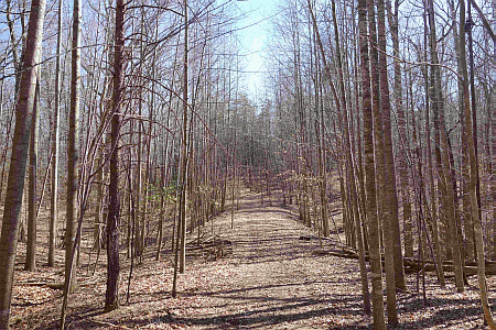
Welcome to orienteering in 2016 with QOC! Come enjoy a full set of courses in this classic QOC terrain, courtesy of Course Setter Jon Campbell. The full range of courses from white (beginner) through blue (advanced) will be on offer. No preregistration is needed, and event timing will be as follows: registration will be open from 10:45am - 1:15pm, you can start anytime between 11am - 1:30pm, and everyone must be out of the woods by 3:00pm.
As usual, youth groups and other large groups planning to attend this event should contact the Event Director in advance so that we can coordinate pre-registration for your group; the group registration and waiver form is part of the information on our Group Leaders page.
Additional information:
- As long as it's dry enough, the nearby mountain bike course is expected to be open (weather dependent), so bring your bike and get a great ride before or after running an orienteering course. PDF map via this page. In case of rain, call the trail hotline at 703-250-9124 to check on status.
- Speaking of the MTB trails: some orange through blue course legs do cross them. You may cross the trails but do not run (or linger) on them.
- Extensive map and course notes are now posted below.
- Carpooling is encouraged as a courtesy to other park users.
- Dogs on leash are welcome.
- GPS watch loaner program continues, for anyone interested in trying one out. See Jon Torrance at the event.
- FYI: at this time of year, the miniature golf course and the marina are closed.
- This event offers day-of registration, but for our Jan. 24 event Quantico Marine Base event, you must sign up in advance between Jan. 1 - Jan. 10. Actual course registration (and payment) will be at the event.
- Feel free to use our Contact Us form if you have any questions!
| Volunteers |
|
||||||||||||||||||||||||||||||||||||||||
|---|---|---|---|---|---|---|---|---|---|---|---|---|---|---|---|---|---|---|---|---|---|---|---|---|---|---|---|---|---|---|---|---|---|---|---|---|---|---|---|---|---|
| Course Details |
|
||||||||||||||||||||||||||||||||||||||||
| Course Notes |
General Terrain Description: typical Mid-Atlantic spur and reentrant terrain, often fairly steep, rising from 37 m to a high of 93 m above sea level on the north side of a reservoir formed by damming the Occoquan River. Generally high to extremely high runnability and visibility, with patches of thicker vegetation and deadfall in varying quantities and of varying size.
Contours: The contour interval is 5m. There is moderately intricate contour detail in small portions of the terrain but topography is mostly characterized by distinct, large to very large spurs and reentrants with subtler contour variations indented here and there into their sides. To show the detail, the map makes ample use of form lines between contours. The bottoms of reentrants can be steeper than they may appear on the map. Trails: The trail network varies from sparse in less visited portions of the terrain to the south, to moderate, to very dense, particularly in a section containing ~10 miles of twisting singletrack for mountain bikers. The single-track gets re-routed from time to time, and there are portions of the trail that are “braided” where the map only shows a single trail. There are also unmapped obstacles on the trails such as a series of bumps, narrow bridges, ramps and even installed rocks on some of the trails. These obstacles can reduce the speed/efficiency advantage that trails usually provide. The mountain bike trails also tend to go up and down more than a hiking trail tends to. Some mapped rides are old road beds and are good to run on. Most of these are easily distinguished having been eroded or cut into the terrain, but some below threshold examples may not be mapped at all or have become ditches. Rocks: Mapped rocks tend to be small, but unique. Mapped cairns can be low. There are many rock piles that are below the cairn threshold that did not make it onto the map. However, some such piles are mapped as stony ground. Out-of-Bounds: A large area marked out-of-bounds along the main park entrance road is an archery zone. There are signs and sometimes streamers along the border of the archery zone. All should keep out. Vegetation: The low vegetation symbols (green vertical stripe or “hash”), both slow running and difficult running, have been used to represent nearly all kinds of deadfall across the map. These symbols are the dominate greens on an otherwise predominantly white forested map. The low vegetation is very well mapped, however the worst of these areas are essentially unpassable and not all that low. The vegetation symbols of light and medium green, tend to be mountain laurel or sapling, and they tend not to slow runners down as much as you might expect. Water: Most of the park is surrounded by the Occoquan Reservoir. The water level is currently high and as mapped. There does not tend to be a band of exposed shoreline allowing easy running around the reservoir. Course Notes The map will be printed at a scale of 1:10,000 for Orange, Brown, Green, and Red. Blue will be printed at 1:15,000 and White and Yellow will be at 1:5,000. All have 5m contours. The safety bearing for all courses is west, in order to relocate (or wait) at the Occoquan shoreline. A large area marked out-of-bounds along the main park entrance road is an archery zone. There are signs and sometimes streamers along the border of the archery zone. All should keep out. The courses all have less than 4% climb, and there are generally options that allow gradual climb. Some climb can be avoided by navigating around large reentrants rather than through them. The courses avoid the steepest terrain, and unless there has been an unusual amount of rainfall, you should not have undue difficulty getting in and out of the reentrants. There are numerous unmapped, temporary tree stands for hunters in the remote sections of the park that the advanced courses visit. Although the park allows archery hunting through February, there is no hunting allowed in the park itself on Sundays. Trails remain fairly visible even with recent leaf acculumation. Speaking of trails, all courses except White and Yellow pass through a sizeable section of the popular single-track mountain biking trails. The trails are open when the trails are dry and closed to bikers when muddy. The trails have been closed most of December. If they are open, cyclist will have the right-of-way on this dense set of painstakingly mapped, and twisting trails — runners are not allowed on these trails. The courses were not set to encourage use of the cycling trails; you may cross them but don't stay on them. It is even somewhat unavoidable for short segments. Be cautious as the cyclists often push their limits riding fast going downhill, on blind curves, and even when going up the hills. The advanced courses all share certain legs, so you should be able to compare times on common legs. Many of the controls are set near to each other in clusters. Be sure to check the control number to avoid punching the wrong control. |
||||||||||||||||||||||||||||||||||||||||
| Registration | No advance registration required. Just show up and have fun! | ||||||||||||||||||||||||||||||||||||||||
| Schedule |
|
||||||||||||||||||||||||||||||||||||||||
| Location | Fountainhead Regional Park, Main parking area, Fairfax Station, Virginia | ||||||||||||||||||||||||||||||||||||||||
| Driving Directions |
Fountainhead Regional Park, Main parking area, Fairfax Station, Virginia
Google Maps Link Apple/iPhone Link One route among several: Take I-95 south of the Beltway, exit at Lorton Road (exit 163), go west 2.1 miles (4th stop light) and at the end of the road take a right onto Route 123. Drive 1.3 miles to Hampton Road, then turn left at the fire station and drive 3 miles to the park entrance on the left. |
||||||||||||||||||||||||||||||||||||||||
| Entry Fees | Individual Entries
Note: juniors = under 21
Team or Group Entries Participants are welcome to compete together as a single team entry. Teams containing one or more nonmembers are charged the nonmember individual rate. Teams containing one or more adults are charged the adult individual rate. For teams to receive member or junior rates, all members of the team must be members or juniors, respectively. Each extra team map beyond the first is an additional $2. Individuals or teams desiring to compete on a second course can do so for a reduced fee of $2/map. Important Notes
|
Course Details
| Course Name | Length (km) | Climb (m) | No. Controls | Scale |
|---|---|---|---|---|
| White | 1.6 | 40 | 8 | |
| Yellow | 2.1 | 80 | 9 | |
| Orange | 4.1 | 135 | 12 | |
| Brown | 4.3 | 160 | 9 | |
| Green | 6 | 210 | 15 | |
| Red | 7.5 | 220 | 14 | |
| Blue | 9.2 | 295 | 20 |
Course Notes
Contours: The contour interval is 5m. There is moderately intricate contour detail in small portions of the terrain but topography is mostly characterized by distinct, large to very large spurs and reentrants with subtler contour variations indented here and there into their sides. To show the detail, the map makes ample use of form lines between contours. The bottoms of reentrants can be steeper than they may appear on the map.
Trails: The trail network varies from sparse in less visited portions of the terrain to the south, to moderate, to very dense, particularly in a section containing ~10 miles of twisting singletrack for mountain bikers. The single-track gets re-routed from time to time, and there are portions of the trail that are “braided” where the map only shows a single trail. There are also unmapped obstacles on the trails such as a series of bumps, narrow bridges, ramps and even installed rocks on some of the trails. These obstacles can reduce the speed/efficiency advantage that trails usually provide. The mountain bike trails also tend to go up and down more than a hiking trail tends to.
Some mapped rides are old road beds and are good to run on. Most of these are easily distinguished having been eroded or cut into the terrain, but some below threshold examples may not be mapped at all or have become ditches.
Rocks: Mapped rocks tend to be small, but unique. Mapped cairns can be low. There are many rock piles that are below the cairn threshold that did not make it onto the map. However, some such piles are mapped as stony ground.
Out-of-Bounds: A large area marked out-of-bounds along the main park entrance road is an archery zone. There are signs and sometimes streamers along the border of the archery zone. All should keep out.
Vegetation: The low vegetation symbols (green vertical stripe or “hash”), both slow running and difficult running, have been used to represent nearly all kinds of deadfall across the map. These symbols are the dominate greens on an otherwise predominantly white forested map. The low vegetation is very well mapped, however the worst of these areas are essentially unpassable and not all that low. The vegetation symbols of light and medium green, tend to be mountain laurel or sapling, and they tend not to slow runners down as much as you might expect.
Water: Most of the park is surrounded by the Occoquan Reservoir. The water level is currently high and as mapped. There does not tend to be a band of exposed shoreline allowing easy running around the reservoir.
Course Notes
The map will be printed at a scale of 1:10,000 for Orange, Brown, Green, and Red. Blue will be printed at 1:15,000 and White and Yellow will be at 1:5,000. All have 5m contours. The safety bearing for all courses is west, in order to relocate (or wait) at the Occoquan shoreline.
A large area marked out-of-bounds along the main park entrance road is an archery zone. There are signs and sometimes streamers along the border of the archery zone. All should keep out.
The courses all have less than 4% climb, and there are generally options that allow gradual climb. Some climb can be avoided by navigating around large reentrants rather than through them. The courses avoid the steepest terrain, and unless there has been an unusual amount of rainfall, you should not have undue difficulty getting in and out of the reentrants. There are numerous unmapped, temporary tree stands for hunters in the remote sections of the park that the advanced courses visit. Although the park allows archery hunting through February, there is no hunting allowed in the park itself on Sundays.
Trails remain fairly visible even with recent leaf acculumation.
Speaking of trails, all courses except White and Yellow pass through a sizeable section of the popular single-track mountain biking trails. The trails are open when the trails are dry and closed to bikers when muddy. The trails have been closed most of December. If they are open, cyclist will have the right-of-way on this dense set of painstakingly mapped, and twisting trails — runners are not allowed on these trails. The courses were not set to encourage use of the cycling trails; you may cross them but don't stay on them. It is even somewhat unavoidable for short segments. Be cautious as the cyclists often push their limits riding fast going downhill, on blind curves, and even when going up the hills.
The advanced courses all share certain legs, so you should be able to compare times on common legs.
Many of the controls are set near to each other in clusters. Be sure to check the control number to avoid punching the wrong control.
Registration
No advance registration required. Just show up and have fun!
Schedule
-
Sunday, January 3
11:00 am - 3:00 pm
Location
Driving Directions
Google Maps Link
Apple/iPhone Link
One route among several: Take I-95 south of the Beltway, exit at Lorton Road (exit 163), go west 2.1 miles (4th stop light) and at the end of the road take a right onto Route 123. Drive 1.3 miles to Hampton Road, then turn left at the fire station and drive 3 miles to the park entrance on the left.
Entry Fees
Individual Entries
Note: juniors = under 21
| Club Member, adult | Club Member, junior | Non-Member, adult | Non-Member, junior | |
|---|---|---|---|---|
| Epunch Owner | $5 | $5 | $10 | $5 |
| Epunch Borrower | $10 | $5 | $15 | $10 |
Team or Group Entries
Participants are welcome to compete together as a single team entry. Teams containing one or more nonmembers are charged the nonmember individual rate. Teams containing one or more adults are charged the adult individual rate. For teams to receive member or junior rates, all members of the team must be members or juniors, respectively. Each extra team map beyond the first is an additional $2. Individuals or teams desiring to compete on a second course can do so for a reduced fee of $2/map.
Important Notes- At the event, we can only accept payment in cash or check; online, you may use a credit card or PayPal account.
- You may become a member at the event or by joining online via this webpage (which also explains the member benefits). Membership is completely optional.
- Most of our events use an 'epunch' timing chip for electronic timing. Individuals or groups without their own epunch pay a higher entry fee (see above), which includes the loan of an epunch for that event. Loaned epunches that are lost incur a $40 replacement fee. Epunches (also known as SI-cards or finger sticks) are usually available for sale at each event as described here.
- Former QOC members who have let their membership lapse pay non-member fees.
- Compasses are available at no charge, but if lost incur a $15 replacement fee.
- Please provide collateral (driver's license or car keys) when borrowing a compass or epunch.
- For additional safety, whistles are available for sale at $1/each.
- Free beginner instruction is always available - just ask at the registration table.



