ShareThis October 5
Sunday
 Pre-registration is required and will open on Monday, Sept. 29 at 6pm and will close at noon Saturday Oct. 4. There will be no day-of registration.
Join Us for an Exciting Family Adventure!
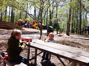
Discover the thrill of map and compass navigation at the upcoming orienteering event at the kid-friendly Cabin John Regional Park on Sunday, October 5!
Acquired by the state of Maryland in 1937, Cabin John Regional Park spans about 500 acres and includes ball fields, an ice rink, a miniature train, and many other amenities. Whether a seasoned competitor or new to the sport, this event offers something for everyone—from kid-friendly beginner courses to advanced routes that challenge even the most experienced orienteers. With beautiful early-fall scenery, a wide variety of courses, and an inviting community atmosphere, this is the perfect opportunity to explore the outdoors, sharpen navigation skills, and enjoy an adventurous day with family and friends.
What to Expect
Participants will navigate through diverse terrains, including wooded areas, open fields, and waterways, using a map and compass. This event is designed to test your navigation skills, endurance, and for groups, teamwork. Various courses will be available to accommodate all skill levels:
- Beginner Courses (white & yellow): Perfect for newcomers, offering a gentle introduction to orienteering with straightforward checkpoints and kid-friendly terrain. Beginner Instruction will be available.
- Intermediate Course (orange): A bit more challenging, great for those with some orienteering experience looking to improve their skills.
- Advanced Courses (brown, green, red & blue): For experienced orienteers seeking a rigorous and demanding course with complex navigation.
Check in will open about 9:45am and courses will open at 10:00am. Everyone must be out of the woods and back at the registration/finish area by 3:00pm when we will begin picking up the controls. Allow yourself time to get back to the registration area and download regardless of whether you have finished. We want to make sure of everyone’s safety and status.
What to Bring
Participants should come prepared with the following items:
- Comfortable outdoor clothing and sturdy footwear
- Water bottle and snacks
- Compass and whistle if you have them. Loaners are available if needed.
Parking Details
Please note how to get from the different parking areas to our registration area at Pavilion A on
this map . QOC signs will point towards Pavilion A from all parking lots.
Groups
QOC allows groups of up to 4 people to orienteer together. Any youth or large groups attending this event should contact the
Event Director in advance so that we can coordinate pre-registration for your group. Details and the required waiver form can be found on our
For Group Leaders webpage.
Post-Event Social
After your run, join fellow orienteers at
Cava , located
here in Cabin John Village, just a mile northwest of Cabin John Regional Park.
| Location | Cabin John Regional Park, Playground Parking Area, Bethesda, MD (Classic) |
| Registration | Advance registration is required. Registration will open at 6pm Monday Sept. 29 and will close at noon Saturday Oct. 4 (the day before the event).
 . .
Who's Registered? Check by clicking here . |
| Start Times | Start times will be by windows (to be defined for this event before registration opens). |
| Schedule | Sunday, October 5| 10:00 am - 3:00 pm | Classic: |
|
| Volunteers | |
| Location Details | Classic
Cabin John Regional Park
Playground Parking Area
Bethesda, MD
Google Map | From the East: Take I-270 North from the I-495 Beltway, exit at Old Georgetown Rd (going north), and then immediately work your way left on Old Georgetown to turn left on Tuckerman. Turn left into the park after the underpass.
From the South: Take I-270 North from the I-495 Beltway, exit at Democracy Blvd, going west. Turn right on Westlake (at the Exxon/Shell station), then eventually left on Tuckerman. Turn left into the park very soon after the left turn onto Tuckerman.
From the North: Going south on I-270, exit at Montrose Rd (west). Turn left to go south on Seven Locks, then eventually left (east) on Tuckerman. Turn right into the park before the second traffic light (and before the underpass).
Google Maps Link
Apple/iPhone Link |
|
| Course Details | Classic| Course Name | Length (km) | Climb (m) | No. Controls | | White | 1.7 | 10 | 8 | | Yellow | 2.2 | 25 | 9 | | Orange | 3.7 | 85 | 13 | | Brown | 4.1 | 55 | 13 | | Green | 5.2 | 65 | 13 | | Red | 6.4 | 100 | 17 | | Blue | 8.3 | 165 | 24 |
|
| Course Notes | Classic Cabin John Creek runs through the park from northeast to southwest, creating a barrier in times of high water, but is normally crossable during this time of year.
The advanced courses have one or two controls that require crossing the creek. At the time of this writing (late September), the creek can be crossed with dry feet near these controls.
The park is rapidly being overrun by thick foliage. Areas that were passable in previous years are now completely blocked with overgrowth, much of it interlaced with thorns. This has constrained course possibilities and control locations, but controls have been placed where they are accessible from at least one direction. A search for a way in that does not involve losing too much skin may be advisable.
On the bright side, the park has an elaborate trail network, which will prove helpful, and trails may often be a better choice, even if longer, than the direct route.
All courses start from the same location, a short walk west from the base at Shelter A. The White and Yellow courses finish at the shelter. The Orange and advanced courses finish at a different point to the east of the shelter, but the walk back to the shelter is not far.
The advanced courses all cross Tuckerman Lane twice. There are two controls at that crossing, one on each side. Watch for traffic and take your time crossing. The time between those two controls will not contribute to your total time. Remember to punch both controls in both directions. |
| Entry Fees | Individual Entries
Note: juniors = under 21
| |
Club Member, adult |
Club Member, junior |
Non-Member, adult |
Non-Member, junior |
|
$10 |
$5 |
$20 |
$5 |
Group Entries
Participants are welcome to orienteer together as a group (up to the maximum for that event; usually 4). Each member of a group is charged their individual rate as shown above, up to a group total of $30 (maximum), and each receives a map. A group receives one epunch. Individuals or groups desiring to compete on a second course after completing their first can do so for a reduced fee of $2/map subject to approval at the event by the Event Director.
Important Notes
- If you wish to become a QOC member you should join online in advance via this webpage (which also explains the member benefits). Membership is completely optional.
- Most of our events use an 'epunch' timing chip for electronic timing. Individuals or groups without their own epunch will be loaned one for that event. Loaned epunches that are lost incur a $40 replacement fee. Epunches (also known as SI-cards or finger sticks) can be purchased from online vendors as described here .
- Former QOC members who have let their membership lapse pay non-member fees.
- Compasses are available at no charge, but if lost incur a $15 replacement fee.
- Please provide collateral (such as car keys) when borrowing a compass or epunch.
- There is no planned, on-site beginner instruction, but beginners are encouraged to watch relevant videos such as this one created by QOC's instructional guru David Onkst
|