Primary tabs
Sunday
Add to Calendar
(not available for past events)
 Pre-registration is required and will open on Monday, Nov. 3 at 6pm and will close at noon Saturday Nov. 8. There will be no day-of registration.
Join Us for an Exciting Family Adventure!
Welcome back to the Marlboro Natural Area, Swanson Road, one of the smaller parks associated with the Patuxent River Park system. Swanson Road provides a mix of mid-Atlantic spur and reentrant terrain, as well as Patuxent River lowlands and marshes. The history of the park remains visible, with unoccupied houses and fields in various stages of natural reclamation. Unlike other near-river parks in our venues, there are many steep areas at Swanson Road, but the climbs are rewarded with open woods, beautiful views, early fall colors, and of course, orienteering courses for all levels.
What to Expect
Participants will navigate diverse terrains, including wooded areas, fields, and waterways, using a map and compass. This event is designed to test your navigation skills, endurance, and for groups, teamwork. Various courses will be available to accommodate all skill levels:- Beginner Course(White, Yellow, and Long Yellow): Perfect for newcomers, offering a gentle introduction to orienteering with straightforward checkpoints and kid-friendly terrain. Beginner Instruction will be available. The Long Yellow course is aimed at those Beginners almost ready to move up a level.
- Intermediate Course (Orange): A bit more challenging, great for those with some orienteering experience looking to improve their skills. This event’s Orange course is aimed at those confident Intermediate Orienteers preparing for their next step.
- Advanced Courses (Beige, Brown, Green, and Blue): For experienced orienteers seeking a course with complex navigation.
What to Bring
Participants should come prepared with the following items:- Comfortable outdoor clothing and sturdy footwear
- Water bottle and snacks
- Compass and whistle if you have them. Loaners are available if needed.
Parking and Check-in
Parking is in the grassy field at the end of the dirt road. Be careful of ruts and mud if it has been raining recently. Check-in, e-punch, and portable toilets will be located at the barn adjacent to the parking area.
Groups
QOC allows groups of up to 4 people to orienteer together. Any youth or large groups attending this event should contact the Event Director in advance so that we can coordinate pre-registration for your group. Details and the required waiver form can be found on our For Group Leaders webpage.| Volunteers |
|
||||||||||||||||||||||||||||||||||||||||||||||||||
|---|---|---|---|---|---|---|---|---|---|---|---|---|---|---|---|---|---|---|---|---|---|---|---|---|---|---|---|---|---|---|---|---|---|---|---|---|---|---|---|---|---|---|---|---|---|---|---|---|---|---|---|
| Course Details |
|
||||||||||||||||||||||||||||||||||||||||||||||||||
| Course Notes |
Swanson Road provides a mix of mid-Atlantic spur and reentrant terrain, combined with Patuxent River lowlands and marshes. Unlike Patuxent River Park, there are many steep areas at Swanson Road. Calculated climbs for each course may be low, depending upon the route choice. Although this year's event will probably occur before the first frost, visibility checks on site were actually a bit better than the map might indicate.
Rootstocks are not shown and none are used for controls. Environmental sample wells are four-inch white plastic pipes scattered throughout the park and are shown on the map as blue Xs. Other man-made special features include trail markers, decorative farm equipment, and the occasional old vehicle or other debris, all shown with black Xs. Some dump sites are not mapped, especially along Swanson Road Spur.
Wavy Leaf Basket Grass Alert 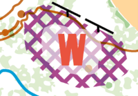
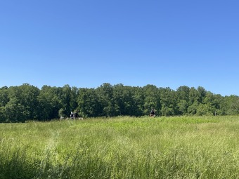
The recently mowed trails around fields near our parking area are shown as rides-slow running. They still have some long grass and cut off saplings, which could make a hard stumble for the incautious. The model aircraft airfield remains out of bounds, except around the edges, which is reflected on all appropriate maps – and no planned route choices should tempt participants to cross the actual airfield – If you feel the urge to sprint across the well-tended grassy open ground… curb that impulse – and stick to the edges. The map has been updated to reflect the most recent status of the fields. In the north of the park, they were planted with sorghum and may be harvested by game day. If they are not harvested, route choices should be available that minimize crop damage by our participants. Planted crop field edges are almost all good running. Fields close to our parking area have been allowed to grow wild with nature working hard to reclaim them. One set of fields that was merely rough open a couple years ago is now full of waist-high blackberry and consequently mapped as dark green. Another field near our parking area has some blackberry, but is more appropriately mapped as rough open-scattered trees. Most non-crop fields have chest-high growth.
Beginner Course Notes: |
||||||||||||||||||||||||||||||||||||||||||||||||||
| Schedule |
|
||||||||||||||||||||||||||||||||||||||||||||||||||
| Location | Swanson Road Natural Area, North end, Upper Marlboro, Maryland | ||||||||||||||||||||||||||||||||||||||||||||||||||
| Driving Directions |
From the Washington Beltway, take exit 11 to MD-4 South/Pennsylvania Avenue. After 8 miles, exit onto US-301 North. Drive 3 miles then turn right onto Swanson Road. Stay on Swanson Road for about half a mile, then instead of turning right for Swanson Road, continue straight onto Swanson Road Spur. Follow Swanson Road Spur for another half mile+ to the parking area.
If your route brings you south on US-301, turn left onto Swanson Road - it's the next junction south of Leeland Road, with the right turn being onto Beech Tree Parkway and the left turn, crossing the highway onto Swanson Road, then follow directions above.
|
Volunteers
- Event Director : Mary Snieckus
- Course Designer : Craig Shelden
- Event Director : Hilary Maloney
Course Details
| Course Name | Length (km) | Climb (m) | No. Controls | Scale |
|---|---|---|---|---|
| White | 1.5 | 35 | 8 | |
| Yellow | 2.4 | 90 | 12 | |
| Yellow Long | 3.6 | 125 | 12 | |
| Orange | 4.9 | 175 | 16 | |
| Beige | 3.2 | 150 | 8 | |
| Brown | 3.8 | 150 | 11 | |
| Green | 5.6 | 200 | 14 | |
| Red | 8.1 | 290 | 17 | |
| Blue | 10.1 | 350 | 22 |
Course Notes
Rootstocks are not shown and none are used for controls.
Environmental sample wells are four-inch white plastic pipes scattered throughout the park and are shown on the map as blue Xs.
Other man-made special features include trail markers, decorative farm equipment, and the occasional old vehicle or other debris, all shown with black Xs. Some dump sites are not mapped, especially along Swanson Road Spur.
Wavy Leaf Basket Grass Alert
During our course design and site checks we found Wavy Leaf Basket Grass for the first time ever at Swanson Road. Courses avoid these areas, but we have marked the basemap with a unique out of bounds symbol to let our participants know where to avoid this invasive weed that limits our use of Patapsco Valley Parks. Here’s the symbol:
The recently mowed trails around fields near our parking area are shown as rides-slow running. They still have some long grass and cut off saplings, which could make a hard stumble for the incautious.
The model aircraft airfield remains out of bounds, except around the edges, which is reflected on all appropriate maps – and no planned route choices should tempt participants to cross the actual airfield – If you feel the urge to sprint across the well-tended grassy open ground… curb that impulse – and stick to the edges.
The map has been updated to reflect the most recent status of the fields. In the north of the park, they were planted with sorghum and may be harvested by game day. If they are not harvested, route choices should be available that minimize crop damage by our participants.
Planted crop field edges are almost all good running.
Fields close to our parking area have been allowed to grow wild with nature working hard to reclaim them. One set of fields that was merely rough open a couple years ago is now full of waist-high blackberry and consequently mapped as dark green. Another field near our parking area has some blackberry, but is more appropriately mapped as rough open-scattered trees.
Most non-crop fields have chest-high growth.
Beginner Course Notes:
For the Beginners, the Green Trail which is used for much of the course has now been mowed, but will probably be
slow running. See note above about recent mowing.
Beginner Course (White 1:5,000) Intended to provide an interesting tour of the Park’s trails near our parking and central operating team area.
Advanced Beginner Course (Yellow 1:5,000) Most controls can be found on or near the designated paths. At least one control requires a bit of off-trail work, but should reward the participant with a fun, hilltop view of our event. For some legs, a willingness to go cross country may yield faster times. Attention to detail will also be important, because some White controls will probably be encountered along the way.
For Yellow runners looking for a challenge, but not ready for Intermediate level courses, the Yellow-Long course may be preferred.
Second Advanced Beginner Course (Yellow-Long 1:7,500) This course is aimed at those Beginners almost ready to move up a level. This course takes a wider loop around the park, has some controls off the trail, but nearby, so they can be reattacked if needed – plus at least one leg that could be an Intermediate (Orange) leg if taken through the woods and not along paths.
Intermediate Course (Orange 1:7,500) This event’s Orange course is aimed at those confident Intermediate
Orienteers preparing for their next step. This course covers much of the middle area of the park and features
prominent landforms, strong handrails, and clear catching features. This course is also intended to give our Intermediate
participants a taste of a slightly more complex presentation by using a two-sided map and should be a great introduction to those looking for a strong Orange test before leveling up.
Advanced Courses
Beige, Brown, 1:7,500
Green, Red, and Blue 1:10,000
Beige: Intended to provide fun orienteering challenges with limited climb and stream crossings. Aggressive, confident Orange runners may find this Beige a fun step up.
Brown, Green, Red, and Blue all use some portion of the relatively new northern portions of the park, with
Blue making full use of the park. Where there are stream crossings, we confirmed that reasonable (feet dry, lower slope) options were available without deviating too far from the leg during site checks. The weather and your route choices may prove us wrong, but we tried.
Brown is a short advanced course designed to keep you off the trail and in the woods.
Green takes advantage of the park’s interior.
Red and Blue maximize use of the park with portions set in northern farmland, then south to a river’s edge view – and wrapping up with a woodland sprint.
Schedule
-
Sunday, November 9
10:00 am - 3:00 pm
Location
Driving Directions
If your route brings you south on US-301, turn left onto Swanson Road - it's the next junction south of Leeland Road, with the right turn being onto Beech Tree Parkway and the left turn, crossing the highway onto Swanson Road, then follow directions above.



