Swanson Road
September 24
Sunday
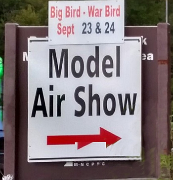
 Welcome back to Swanson Road, one of the smaller parks associated with the Patuxent River Park system. Since the PG Radio Club War Birds event is scheduled for the same weekend, we've moved the QOC event to the north end of the park, with parking along the entrance road. If you need a street address, use 17110 Swanson Rd Spur, Upper Marlboro, MD 20772.
Beginner Instruction: There will be beginner’s instruction, as always, as well. If you are interested and don’t see who is giving it, ask at the registration table. A QOC member will show you how to read a map, teach you how to use a compass with your map and give you hints on how to navigate your choice of course. Besides that, just wear a smile and the clothes you would for a hike or run in a local park. Bring a compass, if you have one, or borrow one at the event.
Dogs (on leash) are welcome too.
Parking: Driving directions are below. Look for the sign (see photo to right) on R. 301 to the Prince George’s Radio Control Club for the turn-off. Due to the PGRC event at the park we will be parking at the north end of the park. Most parking will be along Swanson Road Spur, the entrance road for the park's northern area. Please park compactly to leave room for others and follow directions from QOC volunteers.
Registration opens at 10:45 and ends at 1:15 p.m. People may start anytime between 11 a.m. and 1:30 p.m. Everyone must be back to download by 3 p.m. Don’t forget to download even if you don’t finish, so we don’t need to send out a search party! Wondering about the map and courses? See below for course setter comments about both.
Youth or large groups attending, please contact the Event Director so that we can coordinate pre-registration for your group; the group registration and waiver form is part of the information on our Group Leaders page.
| Location | Swanson Road Natural Area, North end, Upper Marlboro, MD (Classic & Training) | ||||||||||||||||||||||||||||||||||||
| Registration | No advance registration required. Just show up and have fun! | ||||||||||||||||||||||||||||||||||||
| Start Times | You may start your course at any time during the start window listed below for your event. | ||||||||||||||||||||||||||||||||||||
| Schedule | Sunday, September 24
| ||||||||||||||||||||||||||||||||||||
| Volunteers |
| ||||||||||||||||||||||||||||||||||||
| Location Details |
| ||||||||||||||||||||||||||||||||||||
| Course Details | Classic & Training
| ||||||||||||||||||||||||||||||||||||
| Course Notes | Classic & Training Swanson Road provides a mix of mid-Atlantic spur and reentrant terrain, combined with Patuxent River low lands and marshes. Unlike Patuxent River Park, there are many steep areas at Swanson Road. Calculated climbs for each course may be low, depending upon the route choice. Since this year's event will probably occur before the first frost, visibility should be expected to be lower than the map might indicate; and every shade of green on the map will likely be a bit greener ... and white, open forest areas are likely to have some understory. Rootstocks are not shown and none are used for controls. Environmental sample wells are four inch white plastic pipes scattered throughout the park and are shown on the map as blue Xs. Other man-made special features include trail markers, decorative farm equipment, and the occasional old vehicle or other debris, all shown with black Xs. Overall the terrain in the park supports courses tending toward the high end of Orange for maximum difficulty, but the lower visibility will make solid map contact necessary. This is probably not a venue to run up a course difficulty level – but I've tried to offer leg options for skill development, especially for Yellow and Orange. I've also developed two training courses, with some additional challenges for the advanced runners. These training courses use controls for the advanced courses and will be set with epunches and control bags. They should probably be run in place of a regular course. Start and Finish will be co-located for all courses.
Beginner Course Notes:
Intermediate Course Notes:
Advanced Course Notes:
Training Courses: My hope with these is to provide a pair of fun practice challenges in anticipation of the National Meet hosted by QOC in November. | ||||||||||||||||||||||||||||||||||||
| Entry Fees | Individual Entries
Note: juniors = under 21
Team or Group Entries Participants are welcome to compete together as a single team entry. Teams containing one or more nonmembers are charged the nonmember individual rate. Teams containing one or more adults are charged the adult individual rate. For teams to receive member or junior rates, all members of the team must be members or juniors, respectively. Each extra team map beyond the first is an additional $2. Individuals or teams desiring to compete on a second course can do so for a reduced fee of $2/map. Important Notes
|
